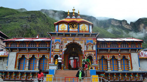
South India Pilgrimage - Badrinath
Structure in the twin mountain series of Nar as well as Narayan in Chamoli district in Uttarakhand, it is the most sacred place among four most important shrines. It is situated along the banks of Alaknanda River. Badrinath Temple along with the impressive Neelkanth Mountain ranges as background setting is a significant destination on the blessed itinerary of each spiritual Hindu. Some time ago this spot was complemented with Badris .
Fast Facts
- Location: Uttarakhand, District- Chamoli, India, Altitude: 3133 meters
- Language: Hindi, English, Garhwali
- Area: 3 km2 (1 sq mi), Elevation: 3,415m (11,204 ft)
- Population: 841 (2001),Density: 280/km2 (725/sq mi)
- Temperature: Summer 22 (Max) & 6(Min) Degrees Celsius Winter 8 (Max) & -6 (Min) Degrees Celsius
- Best Time to visit: May to September

Major Pilgrimage attractions of Badrinath :
Badrinath Temple
- Tapt Kund
- Brahma Kapal
- Neelkanth
- Mata Murti Temple
- Satopanth
- Joshimath
- Alka Puri
How to reach Badrinath?
By Airport : Nearest airport is Jolly Grant (317 kms.) from where you can catch flight to all major cities of India as well other countries.
By Railhead : Nearest railway station is Rishikesh (300 kms.), Kotdwar (327 kms.)
By Road : Well connected to Rishikesh, via buses from Haridwar to Badrinath, Dehradun, Kotdwar and other hill stations of Garhwal and Kumaon region
(Refered to Do Dham and Chardham)
